Agriculture News
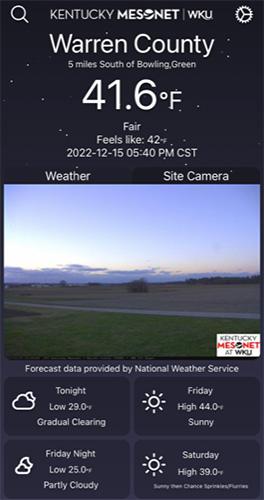
Mesonet camera images now available on Mesonet app
- Friday, February 24th, 2023

The Kentucky Mesonet is now deploying cameras across its network, making it the second statewide mesonet in the country to include real-time photography. Collecting images every 30 minutes, the Mesonet’s photos are now available live (in real-time) on its phone app. Cameras are currently deployed at 24 of the 80 Mesonet stations across the state, with plans to add cameras to the rest of the network throughout the year. All images are collected and archived for posterity, yielding a current total of about 700 GB per day. While photos are collected every 30 minutes during daylight hours currently, the Mesonet plans to increase the frequency of images to one every five minutes and extend photo collection through the night. The Mesonet’s camera has infrared capability to allow for some limited range during the night.
“Meteorological data are essential for weather prediction and warning, but sometimes text data isn’t enough to fully understand what’s going on, especially during high-impact events,” Kentucky Mesonet Director, Dr. Jerry Brotzge, said. “In meteorology, we refer to this holistic understanding as our ‘situational awareness’ and adding real-time photos from the field is an exciting next step to improve our warning capability.”
Dr. Brotzge said that the Mesonet cameras also help organizations like the National Weather Service, TV meteorologists, and other local emergency managers in their tracking of severe weather in Kentucky. The archive provides visual confirmation of what the text data are recording. Brotge says he hopes to integrate the photos and data into the classroom environment.
John Gordon, Meteorologist-in-Charge (MIC) at the Louisville Weather Forecast Office, explained, “The addition of camera photos at Kentucky Mesonet sites is a game changer for NWS operations. These photos will provide forecasters with ‘eyes on the ground’ in parts of the Commonwealth where human observations are sparse, adding critical information which will help in warning and forecast decision-making."
The cameras will also help with data quality. Tiffany Miesel, Kentucky Mesonet Quality Assurance Analyst, stated, “Cameras are the best way to verify precipitation type, especially on days where there is a rain/snow/ice mix. Solar radiation is another variable that is useful to double check with cameras when we have data issues. There may also be days with lots of small amounts of precipitation across the state, and it’s nice to be able to see fog or dew in the images to confirm the reason for it.”
The camera data will also help Kentucky Mesonet field technicians monitor snow depth, grass height, and station security.
The network cameras will help users better understand how to interpret the text data they’re seeing from the Mesonet. As Ms. Miesel explains, “The addition of cameras to the network will help the public associate things like amounts of rain recorded at our stations with what that looks like on the ground. Several inches of rain in one area can cause flooding and several of our stations could show that if we had more cameras. What does 5 inches of rain in Butler County look like? We can show you!”
The expansion and continued operation of the Kentucky Mesonet is possible through the support of Kentucky state government and legislature.
“The additional capability provided by the cameras puts the Kentucky Mesonet in the forefront of weather networks nationally,” Dr. Brotzge said. “With continued collaborations across the state’s public, private and academic sectors, we aim to be much better prepared for the next weather hazards that come our way.”
For more information on the Kentucky Mesonet, contact Dr. Jerry Brotzge at Jerald.brotzge@wku.edu.

