Agriculture News
WKU geologist leads team mapping Gulf of Mexico seabed
- Tuesday, August 16th, 2016
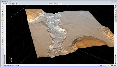
A research team led by Dr. Royhan Gani, Associate Professor of Geology in WKU’s Department of Geography and Geology, has been working on mapping seabed topography and understanding depositional history of the Gulf of Mexico using high resolution 3D seismic data.

A submarine channel, 3.5km wide and 120m deep, exists on the seabed on the continental slope and off the coast of Louisiana, Gulf of Mexico.
The research finding has been included in a recent BBC Natural History documentary titled World’s Weirdest Events.
The documentary highlighted the fact that the fascinating landscape and geomorphology that we see on land can also be seen on the seabed, hidden beneath a thick column of ocean water.
For example, a 120-meter-deep channel, as deep as the mighty Brahmaputra River in Southeast Asia, has been mapped by the Gani team. This submarine river exists on the continental slope off the coast of Louisiana. These findings were recently published in the journal Sedimentary Geology at http://www.sciencedirect.com/science/article/pii/S003707381630166X.
Contact: Royhan Gani, royhan.gani@wku.edu
Some of the links on this page may require additional software to view.

