Biology
WKU group attends annual Kentucky GIS Conference
- Thursday, October 15th, 2015
WKU students, faculty and alumni attended a statewide meeting this week (Oct. 12-14) at the Owensboro Convention Center to share thoughts on new developments and best practices in geographic information systems.
This year’s Kentucky GIS Conference theme addressed pirates and treasure, with geographic information systems (GIS) promoted as Kentucky’s hidden treasure. The conference has been hosted each year by the Kentucky Association of Mapping Professionals (KAMP).

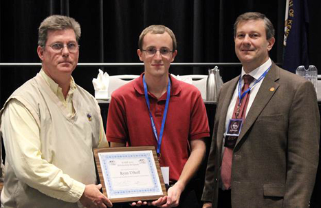
WKU student Ryan Uthoff (center) received the KAMP GIS scholarship from KAMP President Lance Morris (left) and his advisor Kevin Cary (right). (Photo by Christy Powell)
“Unmanned Aerial Vehicles (or UAV) was the topic of discussion at this year’s conference,” said Kevin Cary, Director of WKU’s Center for GIS. “UAVs are used for collecting data for a GIS, whether it be elevation of the land or air photos. The future of UAVs includes flying through sewage pipes and hallways as well as relaying WiFi or cell phone signals among distant towers in a controlled airspace.”
Ryan Uthoff, a senior from Franklin, Tennessee, presented his research at the conference and was recognized during the luncheon as this year’s KAMP GIS scholarship winner. Uthoff presented his FUSE (Faculty-Undergraduate Student Engagement) research on mapping high tunnels in Kentucky. The $1,000 scholarship was presented by KAMP officials, and it also covered conference registration and hotel lodging in Owensboro. This marks the third year in a row that WKU has had a student win the scholarship since its inauguration in 2013.
Lamar Coats, a graduate student in the geoscience program from Antioch, Tennessee, presented a portion of his research on The Influence of Tropical Cyclones on Droughts and Warm Season Precipitation in Tennessee and Kentucky using GIS tracking techniques and spatial statistics.
Selva Calderon, a senior from Bowling Green minoring in GIS, presented on Breastfeeding Resource Centers in Warren County using online web mapping techniques for gathering and disseminating spatial information.
Scott Dobler, Instructor of Geography and Coordinator of the Kentucky Geographic Alliance (KGA), participated in a panel discussion on Jobs in the Geospatial Sector: The Pipeline from Education to Practical Employment. He was also the committee chair for the map competition and presented the awards to the contestants during the luncheon.

The WKU group that attended the Kentucky GIS Conference included (from left) Scott Dobler, Eric Anderson, Beau Spencer, Ryan Uthoff, Kevin Cary and Keith Koerner. (Photo by Kevin Cary)
Kevin Cary presented on Automating Raster Map Services in ArcGIS for Servers, using Kentucky Mesonet data for viewing purposes in a web map over continuous space. His web map application can be viewed at http://gisapps.wku.edu/flexviewers/expdrought/
Also in attendance were Eric Anderson, a senior GIScience major from Bowling Green; Keith Koerner, a senior from Louisville minoring in GIS; and Beaux Spencer, a student in the graduate certificate in GIScience program from Bowling Green.
Several GIS alumni also were in attendance, including Tim Rink with Stantec; Jon Hall with the Army Corps of Engineers; Danny Hendron with Pictometry (who is now part of KAMP’s Board of Directors); and Ashley Hitt with Connected Nation, who won a KAMP service to the community award.
For information on GIS, visit http://www.wku.edu/gis or contact Kevin Cary in the WKU’s Center for GIS at (270) 745-2981 or kevin.cary@wku.edu
Contact: Kevin Cary, (270) 745-2981
Some of the links on this page may require additional software to view.

