WKU News
3 GIS alumni assist in post-hurricane recovery in Puerto Rico
- WKU GIS Program
- Tuesday, November 21st, 2017

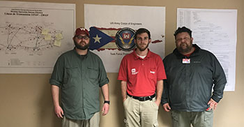
From left: WKU GIS alumni Matthew Brunt, Tyler Jamison and Jess Cary are assisting in post-hurricane recovery efforts in Puerto Rico. All three work with the U.S. Army Corps of Engineers.
Three alumni from WKU’s Department of Geography and Geology who work for the U.S. Army Corps of Engineers (USACE) have been assigned to Puerto Rico to assist in post-hurricane recovery efforts.
Tyler Jamison of Mount Eden, Matthew Brunt of Bowling Green and Jess Cary of Bowling Green are helping to repair the hurricane-damaged electrical power grid in Puerto Rico. They were deployed to Puerto Rico with Task Force Restore Power San Juan to use Geographic Information Systems (GIS) by providing the central office and field offices access to spatial data, technical support and data requests.
Jamison, a 2016 graduate with a bachelor’s degree in Geography and GIS Certificate, is a Geographic Information Systems (GIS) Specialist with the USACE Louisville District. Brunt, a 2009 graduate with a master’s degree in Geoscience and GIS Graduate Certificate, is a Cartographer with the USACE Nashville District. Cary, a 2013 graduate with a master’s degree in Geoscience and GIS Graduate Certificate, is a Realty Specialist with the USACE Nashville District.
Jamison’s and Brunt’s activities include map production, custom graphics, capturing/entering data and analyzing data to identify spatial relationships. Cary’s activities include using GIS for managing spatial data and creating maps for real estate actions for power grid repair such as temporary work areas, leases and right of entries.
“Our alumni’s activities demonstrate the value and importance of a spatial perspective on natural-disaster recovery efforts,” said Dr. David Keeling, University Distinguished Professor of Geography. “Their GIS skills are facilitating a very localized and mappable understanding of power infrastructure and delivery challenges in Puerto Rico. As has been widely reported, the majority of Puerto Rico’s population remains without power weeks after the hurricane, and GIS is helping to speed along the recovery and rebuilding efforts.
“Careers utilizing GIS skills are among the most attractive, well-paying and exciting opportunities for students seeking meaningful employment after graduation. As these efforts by our alumni in Puerto Rico demonstrate, having strong GIS skills literally can help save lives and rebuild infrastructure after a natural disaster.”
For information on GIS at WKU, visit http://www.wku.edu/gis or contact Kevin Cary in the WKU’s Center for GIS at (270) 745-2981 or kevin.cary@wku.edu
Contact: Kevin Cary, (270) 745-2981
Some of the links on this page may require additional software to view.

