Ogden News
WKU alumni, students, faculty attend annual Kentucky GIS Conference
- WKU GIS
- Tuesday, October 30th, 2018

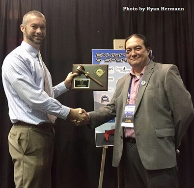
WKU graduate Stephen Chino (right) is the new president of the Kentucky Association of Mapping Professionals. He presented Louis Hill (left) with a past president plaque during the Kentucky Geographic Systems Conference in Bowling Green.
WKU alumni, students and faculty attended this year’s Kentucky Geographic Information Systems (GIS) Conference Oct. 23-25 in Bowling Green. WKU alumni had a far greater presence than in previous years, illustrating the growing importance of GIS and locational intelligence in the wider Kentucky economy.
Each year, a city is selected in the Commonwealth to host Kentucky’s annual GIS conference for GIS users, educators, and professionals to discuss the latest GIS technology as it relates directly to new and existing projects impacting Kentucky and beyond. This year’s conference theme was “Rev Up with GIS in the Vette City.” For the past decade, the Kentucky Association of Mapping Professionals (KAMP) has organized Kentucky’s annual GIS conference.
During the conference’s luncheon a digital survey was conducted with the conference’s attendees to determine which Kentucky college or university they attended last. WKU had the largest share of attendees.
As the conference came to an end, Stephen Chino took over as KAMP’s new president. Chino, a 1999 graduate of WKU’s Geography program, has more than 20 years of experience in the fields of GIS, GPS and Geomatics. He is a licensed Land Surveyor in Kentucky and is the GIS Manager for the City of Paducah’s enterprise GIS.
Each year, awards are given out at the conference recognizing KAMP members for their outstanding service and achievements.
- Scott Dobler, an instructor of GIS & Geography at WKU and Coordinator of the Kentucky Geographic Alliance, received the Service to the GIS/Mapping Community award that recognizes a KAMP member who has demonstrated significant contributions to Kentucky’s GIS and mapping community.
- In 2009, WKU’s GIS program won the Exemplary System Award, which recognizes an outstanding GIS or mapping program in the Commonwealth of Kentucky. WKU is the first institution in Kentucky’s higher education system to offer a Certificate in GIS, GIS Minor, GIS Major, and Graduate Certificate in GIS. By the year 2020, the GIS market is expected to reach $88.8 billion; in 2017 it was at $66.2 billion. The expected outlook in the growth of jobs in GIS (Cartography and Photogrammetry) by the Occupational Outlook Handbook (U.S. Bureau of Labor Statistics) is much faster than average between 2014 and 2024.
- This year’s winner of KAMP’s statewide GIS scholarship was WKU student Hannah Caudill, who is working toward her Certificate in GIS while majoring in Geography/Environmental Studies. The GIS scholarship awards $1,000 that includes a one-year membership with KAMP and full conference registration. She was honored during the conference luncheon with the KAMP President Louis Hill presenting the scholarship award.
- David Evans, GIS Coordinator at the City of Bardstown and a 2011 graduate of WKU’s Department of Geography and Geology GIScience program, presented Bardstown Historical Walking Tour Story Map, detailing the planning that went into the tours, how information complied was translated into story maps, limitations of mobile maps, and lessons learned.
- Ashley Hitt, Director of GIS Services and a graduate (’05, ’07) of WKU’s Department of Geography and Geology programs in GIS, Geography and Geoscience, presented Analyzing Broadband Deployment Data to Enhance Community Planning showcasing how data-driven communities rely on accurate and granular geospatial data and the development of the Broadband Confidence Rating and Broadband access at the census block level.
- Chandler Callison, GIS Technician at Warren County Water District and a graduate (’14, ’16) of WKU’s programs in GIS, Geography and Geoscience, and BJ Malone, GIS/IT Systems Supervisor at Warren County Water District and a graduate (’99) of WKU’s civil engineering tech program, presented The GIS Role in Advanced Metering Project discussing the usage of mobile GIS/GPS applications for updating/collecting meter locations and creating web apps for serving project data to end users.
- Andrew Reeder, Advanced GIS Analyst at BGMU and a graduate (’09, ’16) of WKU’s programs in GIS, Geology and Geoscience, presented Bowling Green Municipal Utilities Infrastructure Condition Analytics using spatial analytical and geoprocessing tools for scoring and tracking the general conditions of the criticality of new and aging infrastructure for a proactive maintenance strategy.
- Kevin Cary, Instructor of GIS & Geography and GIS Director, presented Geotechnologies in a Global Community, a Colonnade course introducing students to collecting and integrating spatial data into discipline specific issues through online web mapping and story maps by examining the spatial variability from a local to global scale.
- Scott Dobler presented Geo-Inquiry in Kentucky Schools, introducing the five-step Geo-Inquiry process modeling the K-12 standards developed for education.
For information on GIS, visit https://www.wku.edu/gis/ or contact Kevin Cary in the WKU’s Center for GIS at (270) 745-2981 or kevin.cary@wku.edu
Contact: Kevin Cary, (270) 745-2981
Some of the links on this page may require additional software to view.

